BAHAMAS - EXUMA'S FROM SHROUD CAY TO STANIEL CAY

Circled in red is the northern portion of the Exuma Island chain, which is what this blog covers. The red dots are where we have anchored so far and the red "X" is where we are now, on the east side of Long Island.

The Exuma Island chain is 130 miles long with Great Exuma Island being the largest at 37 miles in length and having a population of around 8,000. Exuma was settled in 1783 by American loyalists fleeing the Revolutionary War. The Exuma capital of George Town was named in honor of George III.

After crossing the Tongue of the Ocean with depths of over 6000' we arrived onto the Great Bahama Banks, which is often less than 10' deep. That's the shadow of the Starship's mast on the sea floor. I normally set our shallow water alarm at 10', so cruising in these waters takes some getting used to.

For navigation we use a combination of our Garmin chart plotter, Navionics on an Android tablet, Google Earth on an I-Pad and paper charts.

The problem is, ALL of these navigational charts, whether paper or electronic, have disclaimers regarding their accuracy.


So you really have to learn how to read the many shades of blue to have an idea of water depth. However, the same depth will be a different shade of blue depending on whether the bottom is sand, vegetation, rock or coral. Plus, shadows from clouds can look very similar to vegetation, rock and/or coral. Of course you also have tides which move up or down 3'.

Also, the time of day makes a big difference, not only regarding tides, but also the sun's position. As this photo shows, when the sun's in front of you, you really can't read the water at all.

So when going through particularly tight spots it's important to time it when the sun is above or behind you. This photo is basically the same view as the one above, but the channel turned just enough to put the sun a little behind us. Now you can clearly see the deeper water of the cut. As far as cuts go, they are further complicated by how the tidal currents interact with the waves coming from the outside. Sometimes with incoming waves and outgoing tide cuts can be impassible.

Now that I have you believing that I must be some kind of navigational genius to avoid running aground all the time, let me throw in human error. Me being the human in this case. These are a few underwater photos of our port keel after arriving in Shroud Cay of the Exuma Island chain.
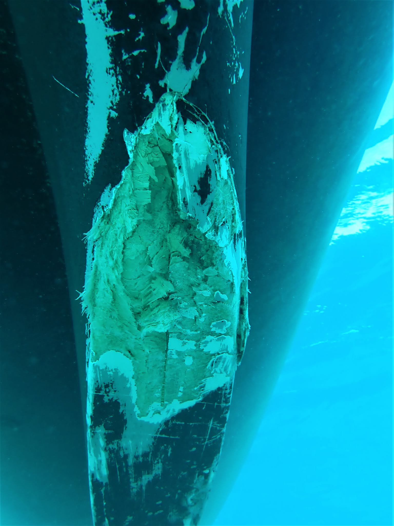
As we were coming out of Lisbon Creek and leaving Mangrove Cay at about 4 knots, I hit a rock that clearly shouldn't had been there. After the collision I backed off and we continued to the Exuma Island chain 50 miles to the east. Because of a previous experience I wasn't that concerned about taking on water/staying afloat. Coming down the Mississippi in October 2017 with Al and Clancy on-board, I hit the end of a submerged wing dam south of St Louis with the starboard keel. The impact was so hard that it spun us completely around. In this case the impact wasn't nearly as severe, so I figured there was far less damage. From my previous experience I learned that the way Starship was built, the keels are full of buoyant foam, so staying afloat or even listing was never an issue. However, Delana wasn't convinced. After the wing dam encounter, I had it temporarily fixed in Paducah, Kentucky, but it wasn't permanently repaired until we got to Alabama. Anyway, from Shroud Cay we were able to make arrangements to have the keel damage repaired by a guy who was currently in Ft Lauderdale, but would be coming back to his home base on an island about 30 miles south of where we were anchored.

Everyone who said, "If you think this is pretty water, just wait until you get to the Exumas" was right. It is absolutely beautiful. This is a tidal creek that flows through Shroud Cay, which is the northern most cay within the Exuma Cays Land and Sea National Park.


The creek had a bunch of turtles in it.

At Shroud Cay there was a small reef near where we were anchored, so we went snorkeling for only the second time since being in the Bahamas. It had just been too cold. Here's a nice school of big Atlantic spade fish.

This is me sneaking up on a sleeping nurse shark. As far as sharks go, the only ones we saw in Central America were nurse sharks. However in Bimini, we saw a LOT of bulls and hammerheads. We've seen a few since too. This, along with the coolish weather, has made Delana a little apprehensive about snorkeling, something we often did a couple times a day in Honduras and Belize. While in Bimini, Jay (the shark wrangler) gave us a pep talk on how sharks are misunderstood and are really just curious, which I'm sure is true. Unfortunately, he also told us that he and his colleagues have been bitten multiple times over the years. Something about how since sharks don't have hands they have to use their mouths, to check things out, including people. The problem is, they're mouths have TEETH. I'm sure as it gets warmer and we want to get in the water more, Delana will get over this shark thing.

When we first arrived at the Shroud Cay anchorage we were the only boat there. By the time we left there were 20. This is when I first recognized that Starship is no longer the nicest boat in the anchorage, which was often the case in Central America. I think the reason is a combination of things: 1. There are a lot of nice boats in Florida that come to the Bahamas. 2. The Bahamas is where a lot of boats begin their circumnavigation of the Caribbean, at which time they're is as good a condition as they'll ever be. 3. By the time boats that are circumnavigating the Caribbean get to the western Caribbean they are older and more used. 4. Starship isn't getting any younger.

Next we went to Warderick Wells which is also in the Land and Sea Park. They have a 53' skeleton from a sperm whale that had washed up on shore.

These are Bahamian hutia. They're nocturnal, about the size of a rabbit and are the only mammal native to the Bahamas. They were thought to be extinct until a colony was discovered in 1966. According to a Park employee, hutias were first introduced to Warderick Cay in the early 80's. Twenty years later almost all of the vegetation was eaten and it was estimated that 850,000 hutia lived on the island. I don't know what they did but the vegetation is definitely back, even though there doesn't seem to be any shortage of hutia.

This is Boo Boo Hill, so named because it is haunted by the crew of a schooner that sunk nearby with all aboard. No bodies were ever recovered. The tradition is that to assure a safe journey any boat that visits Warderick Wells should climb up to Boo Boo Hill and leave a piece of wood with their boat's name on it.

A more recent tradition is that anyone wanting a cell signal also goes to the top of Boo Boo Hill. This really wasn't staged. Once outside the Park, cellular coverage is really pretty good.

The Park has a string of mooring balls down the center of a tidal creek that has a very strong current. Starship is on the right.

These are other boats moored on balls in the same creek.

One day we want on a long walk on a supposed "trail". It's all rock so foot traffic really doesn't leave a path to follow. And of course there are no signs. However, at first there were yellow spots spray painted on the rocks to follow. Then when they ran out of paint they started making pyramids of rocks to lead the way. At first the pyramids would be 3' or so tall, but as we kept hiking they became smaller and smaller until they'd be made up of just two or three rocks. It made for an interesting hike both coming and going.

We came across some nice views.

But the plantation "walls" and "ruins" were a little underwhelming. They also highlighted what a tough land this has always been. In many cases people were given the land but without soil or water it was still very difficult to survive.


Before leaving Warderick we made and left a sign showing that Starship II had been there.


This isn't my photo, but we did see this smoke from our next anchorage at Bell Island. A few days later we found out its source.

From Bell we were able to dinghy to "The Aquarium", which is suppose to be the best snorkeling spot in the Exumas.


There were a few nice fish and some live coral, but the entire area was on the south side of a small rock island and was only about 20 yards by 20 yards. I'm afraid the snorkeling in Honduras and Belize has really spoiled us.

Then we made the mistake of swimming to the other side of the rock island to see if there was more sea life and fewer people. Getting there was fine and we did see a nice ray and a trigger fish together. However, because the current was so strong we absolutely could not swim back to where we started and where our dinghy still was. As hard as we tried we just couldn't do it. So we ended up pulling ourselves hand over hand using the sharp rock every island is made of as hand holds. A good lesson.
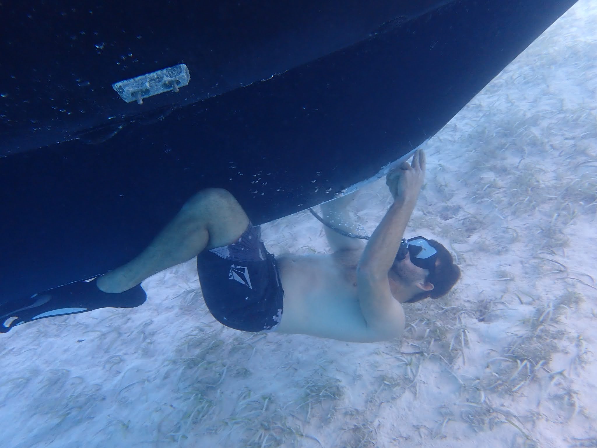
Next we anchored by Sampson Cay, where David Mitchell, a third generation Bahamian and owner of Overseas Salvage, is based. He came over in his skiff and went right to work.

David used a two part epoxy that can set up under water, along with a diving tank, hose and regulator so he could stay under for as long as he needed. First he cleaned up the damage and then slowly worked the epoxy in bit by bit until the hole was filled and the damaged area matched up with the rest of the keel surfaces. He really did a nice job. Hopefully it'll hold until we get back to the Chesapeake in June.

David Mitchell has my dream life. He was raised at a marina on a cay, boating and exploring everyday; owns a private island with its own landing strip; has an airplane and several boats; flies or boats at a moments notice to go surfing or diving; lives totally off the grid; and just works a few salvage jobs a year that pay very well. By the way, for some reason Delana began sleeping much better after the repair.

Compass Cay Marina feeds the nursed sharks and charges people pay to swim with them. They really seem to enjoy being rubbed, but who doesn't.


Remember that plume of smoke from a few photos back? While at Compass Cay Marina one of the staff shared this photo with me. It's a fairly new 65' power yacht that had caught fire while at the dock. The flames engulfed the boat so quickly that they didn't have time to fight it, so they quickly towed it out into the bay to protect the other boats, as well as the marina. There it burned to below the water line.

This is all that was left of their yacht by the time the owners returned from dinghying to town and back.

Though this may look like one, there are no fresh water streams, creeks or rivers in the Bahamas. The source of this water are waves that break over the east side of Compass Cay and then flow through the island to the west side. When David (the guy who repaired the keel) was a kid, he and buddies use to come here and play in the pool under the surf as it crashes over. They called it the "waterfall". Then one day they arrived and noticed someone had put up a sign calling it "Rachel's Bubbles". The boys were pretty upset with the name change and boycotted it for a time.


A large percentage of the islands are private. Some have homes, some resorts and some with nothing. Regardless, they all have to be self sufficient. We met the guy who used to take care of the wind turbines on this island that included a a very high end resort. He said when the wealthy guests came, the support staff were expected to remain out of sight. However, there were also times when there were no guests and the staff had the run of the place.

This guy on an electric hydrofoil surfboard came through the anchorage at Sampson Cay. Though the photo is lousy, it looked pretty fun. It no doubt came from one of the mega yachts which carry all sorts of toys.

We've been told that Covid restrictions have closed so many of the mega yacht cruising grounds in the Caribbean and the Mediterranean, that they are all congregating in the Bahamas this year, which is unusual.

This one is Gladiator. It's about 150' long, has a crew of 11, can accommodate 10 guests and rents for $220,000 per week, plus expenses. We've seen some that rent for twice that per week. If you would like to see photos and other information about it, go to www.y.co/yacht-charter/gladiator. The mega yachts are pretty amazing.

With a strong cold front in the forecast we left our cozy little anchorage in Sampson Cay and headed to the west side of Big Majors Cay. At least 45 other boats had the same idea.

Many of whom get together on the beach for happy hour.

At night all of the anchor lights were really pretty. Our starfield.

While there a couple we had met at the marina in Guatemala came over. He replaced the membrane on our water maker. It was really a pretty easy job but membranes are expensive and seeing how they only need to be replaced every 6-10 years, I figured it was better to have it done by someone whose done it before.

A couple miles away is Staniel Cay, which has a town with stores, restaurants, fuel, propane, etc. and is kind of a cruisers' hang-out.

These kids at the Staniel Cay Yacht Club are playing with the nurse sharks, and visa-versa.

Some cute rentals.

Grocery store options, with the "blue store" on the left and the "pink store" on the right.

This is what the "pink store", though it had blue paint, had to offer.

Between Big Major Cay and Staniel is Thunderball Grotto. It's name after the James Bond movie Thunderball because some scenes from the movie were filmed in it.

It was pretty cool. Unless you enjoy swimming through dark underwater passages while holding your breath, the best time to go is during low tide.


Okay, just a few minutes before this photo was taken, Delana and I had a 50% chance of losing our lives or at least being very seriously injured. I'm not kidding. This truck loaded with rock was about at this spot when its engine died and it started rolling backwards. unchecked. down the hill. Our backs were to it. We obviously had no way of knowing which way the driver might turn, so it was just pure chance that we both ran left and the driver steered right into some trees, which stopped him.

If we had gone the other way, there was a cemetery conveniently located at the bottom of the hill.

Not a bad business model.

On the island next to our anchorage there are pigs. As a matter of fact, when David (the guy who repaired the keel) was a kid, every morning before school his job was to sail down with scraps from the marina his parents owned and feed the pigs. So he may have started all this. He said everyone thought it strange when tourists started coming to see the pigs. "We thought all pigs swam", he said.

Anyway, some will swim out to boats that come nearby to get treats. This one's kind of cute.

This one is far less charming. Some were pretty aggressive. We had a friend get bitten and had heard stories about them wrecking dinghies, so we didn't get too close.

We've seen quite a few nice rainbows, but really very little rain.

Ever since we arrived in the Exumas, all of our sails have been very short, only two to five hours long. That's really been nice. Next time we'll cover the our time beginning in the real Bahamian settlement of Black Point to the Bahamian sailing mecca of Georgetown.


Comments
Post a Comment